
The objective was to better understand nature and goals of data providers, to share respective experience to find new ways to perpetuate the measurement sites and enhance the data's value.
Cerema created and has been operating the French national coastal wave measurement observatory (including a significant part of the measurement network for wind-sea and swell), referred to as Candhis (Centre d’Archivage National des Données de Houle In Situ :
Toward a community of the sea states observatories

Cerema’s efforts aims at developing an integrated national information system on sea states, ensuring the production, capitalization and dissemination of data and value-added services to end-users as well as facilitating the exchanges in the user communities and between the different stakeholders.
In 2021, Cerema carried out an international benchmark on coastal wave measurement networks and observatories funded by the French National Research Agency. The objective was to produce a comprehensive update on practices to help guide the Candhis network development strategy.
The aim of the webinar was to share key information with international community, in particular with the various parties involved in this kind of network. This enabled to better understand the nature and the objectives of data providers, to share their respective experience, to find new ways to maintain measurement sites and to bring further added value to data.
The webinar also initiated a direct dialogue between data providers and users so as to better take into account their needs and expectations, while pointing out the challenges that lie ahead.
Program of the webinar:
Introduction
From Ms Charlotte Le Bris, Chief engineer, Science and Technology and European and International Affairs Department, Cerema and Dr Sébastien Dupray, Deputy director, Technical directorate Water, Sea and Rivers, Cerema.
Presentation of Cerema, an overall approach to land use planning for a resilient future. Cerema is a bridge between stakeholders, research and public policies. With a dynamic strategic based on resilience (to reduce vulnerabilities), adaptation to climate change and a new organisation to increase efficiency and responsiveness.Waves study in Cerema is included in a global coastal and maritime activities.
Candhis, the french observatory of wave measurement is one part of this activitie with objectives to open Candhis to international partenerships and to be the reference in France for wave data providers and end-users needs.
Perspective from the Netherlands
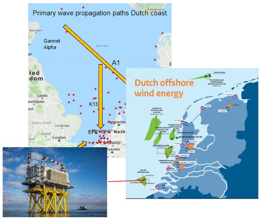 From Mr Pieter Haaring, Expert on information systems at Rijkswaterstaat and Mr Robert Slomp, Software coordinator for flood risk management at Rijkswaterstaat
An operational wave measurement network for shippings and offshore activities flood defences. Wave measurement from buoys, poles and oil & gas and windpark substation platforms.
Different networks for special purposes : in sea, estuaries and large lakes.
And some special projects like Petten 1995-2013 for measuring waves and run-up for flood defences design.
Perspective from USA
From Ms Julie Thomas,Program Manager (Retired)/Senior Advisor, Coastal Data Information Program (CDIP), Chair of NOAA’s National Ocean Services Hydrographic Services Review Panel
Presentation of the coastal data information program with 67 active wave stations, 294 stations deployed since 1975. Data sent to the National Data buoy Center and distributed to National Weather Service for broadcast on their marine weather channel.
Use of waverider buoys with maintenance, calibration, quality control and dissimiation realized by CDIP. Many products are available in Internet (spectra, parameters, displacement path, hurricane and large storm events…).

Perspective from England
 From Dr Thomas Dhoop, Project Manager | Coastal Scientist, Channel Coastal Observatory, National Network of Regional Coastal Monitoring Programmes
Wave measurement as a part of the national network of regional coastal monitoring programmes, providing the underpinning for flood and coastal erosion risk management in England.
37 wave buoys. Maintenance work contracted to Fugro GB Marine Ltd. Data collected, quality-controlled and distributed by the Channel Coastal Observatory. Real time data and analysis outputs available in Channel Coastal Observatory website.
Perspective from Finland
From Mr Antti Kangas, Head of Oceanographic Services, Finnish Meteorological Institute (FMI)
Wave measurement in Baltic Sea for marine warnings, sea state monitoring, wave modelling and wave research. Three different products : observations, forecasts and warnings.
Start of measurements in 1973 with nowadays 5 waverider buoys, completed by long term or short term research measurements at different locations. Data available from the FMI open data portal in real time.

Perspective from Belgium
From Mr Johan Vercruysse, Project engineer, Vlaamse overheid, Agentschap maritieme dienstverlening en kust, Afdeling Kust
A monitoring network at sea with measurement platforms and buoys, and on the coast with tide gauge stations, meteostations, windlocations and measurements in the harbors. Wave measurement from fixed platforms (radar) and buoys (waverider and beacon buoys). All data available from Meetnet Vlaamse Banken website.
Perspective from Italy
 From Dr Arianna Orasi, Dipartimento di Tutela delle Acque Interne e Marine, National Centre for Coastal Zone Protection and Characterization, Marine Climatology and for Operational (ISPRA)
Evolution of the italian wave buoys network during the last 30 years, with the different of type of waveriders buoys used.
The present network has been revamped at the beginning of 2021 after a long periof of stop, with seven new moored metocean buoys (RON network). Data available on RON website.
Perspective from Iceland
From Mr G Orri Gröndal, Hydrographic surveyor, Vegagerðin, Icelandic Roads and Coastal Administration
An information system for seafarers in real time (wave buoys, anemometer, tide gauge) and for predictions. It’s included 11 waverider buoys. All data are available on Iceland wave website.
Perspective from Portugal
From Ms Rita Esteves, Data Buoy Manager, Hydrographic Institute - Portuguese Navy
A real-time networks with HF radar, moored buoys (16 met-ocean and costal buoys with wave measurement) and tide gauge. Real-time data transmitted to GTS and available on Geomar Hidrografico website for society (nautical sports, tourism…), private sector (renewable energy, port construction…), public sector (maritime safety, coastal erosion…).
Extrem weather and climate change analysis.
Perspective from France
From Dr Xavier Kergadallan, Projet manager, Technical directorate Water, Sea and Rivers, Cerema
Presentation of Candhis, the french national coastal wave observatory with 35 waverider buoys and an information system for dissimination of real-time and stored data, distribution to the national monitoring system and international program. Wave data and analysis available on Cerema website.

Use of sea state data in engineering and research and development
From Dr Luc Hamm, Technical director, Artelia Maritime
Two example of using wave data. First in engineering with use of Candhis data for validation of wave boundary conditions of a local model in Loire estuary in France.
Second in research with a study of complex sea-states in bay of Seine in France. Presentation of present and future needs of the end-users.
Le replay :