
The Polder 2CS research project brings together 13 Dutch Belgian and French partners and numerous public and private observers[1] involved in coastal management. It aims to improve the adaptation of the coastline to impacts of climate change and focuses on 4 main issues issues:
-
defense against floods and submersions,
-
crisis management,
-
knowledge of infrastructures
-
the construction of a platform for exchange between scientists and the public about the protection against marine submersions and floods.
Tests on a 6 km² polder

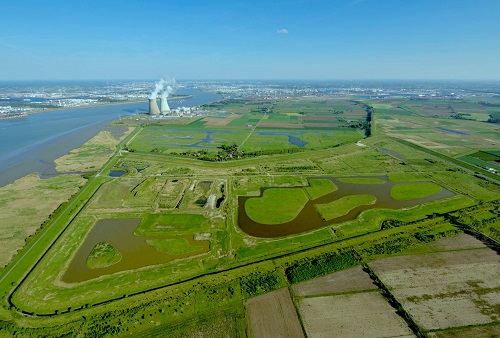
The project benefits from an exceptional location near Antwerp between Belgium and the Netherlands, where a 6 km² polder is to be returned to the to the sea. A new dike is being built further inland, allowing for rupture or resistance tests on the on the old tidal dike, which is a 3 km long tidal protection dike, and thus to test solutions for maintenance, repair or flood management solutions.
The Hedwige and Prosper polder can be put under water in a controlled to study of a controlled flooding and of the protection behaviour of the protective structures, even under extreme conditions. The area has been divided into into 11 sections to carry out different experiments.
The Two Seas region, which stretches from the south of the Netherlands to the north of France, is made up of low-lying areas and is being impacted more by climate change. The Interreg Polder 2CS project aims to develop the adaptation capacities of these areas with an important component on informing stakeholders, including about risks and coastal management methods, as well as to identify sustainable solutions for preservation of the coastline.
Work is being carried out on the knowledge and the improvement of protection systems (dykes, polders, controlled flooding, etc.) and their implementation, as well as on the development of a shared strategy, particularly in terms of emergency response.
Through this project, the collaboration between the stakeholders from the partner countries will be strengthened, and a digital platform will promote the exchange and sharing of operational knowledge.

To develop knowledge of flood risks, Cerema has contributed to several aspects of the project, in particular the validation of the solutions tested within the framework of the project, the tests resistance of dykes by flooding, tests of dyke failure or flooding followed in real time according to different scenarios, the dissemination of the results to the public in a targeted manner.
Cerema Hauts de France, Normandie Centre and Cerema Mer are involved in the project with in particular the mobilization of two research teams: HA (Hydraulics for Development) and ENDSUM (Non Destructive Evaluation of Structures and Materials).
These tests will allow for more accurate models to be developed to predict the mechanism of flooding and of floods and the behaviour of dikes.
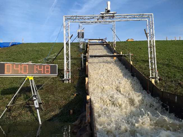
Submergence tests have been carried out from October to December 2020 and in February-March 2021 and allowed to improve the hydrodynamic and erosion prediction models of dikes. These tests contribute to improve the knowledge, particularly on dikes that are destined to be overtopped when the water reaches a certain level, in order to reduce the load on downstream structures.
The actions of Cerema
Geophysical and remote sensing observations by drone on the old dike of the polder
Thanks to images taken by a drone combined with measurements by the ERT (Electrical Resistivity Tomography) to determine the resistivity of the different materials present in the dike and radar measurements, a topographic model of the area and of the dike was developed.
These data on the structure of the dyke have made it possible to build a 3D model of the dike, necessary for the experiments on the site.

Numerical overflow models
Several numerical models have been tested to reproduce the tested to reproduce the overtopping of the dike and the water flow. Some tests were then performed in situ with different dike configurations, for example the presence or not of anomalies (tree, embankment, burrows, ...), the presence of previous repairs and the height of the grass.
This work, which will continue in order to refine the numerical models should make it possible to determine the water depth and flow velocity on the slope of a dike during an overflow.
The figures below shows on the one hand the experimental experimental set-up and the results of the modelling obtained by Cerema (1D SVE and 2D Star CCM+). The results of Cerema are very close to the results obtained results obtained by the other European teams.


models developed at Cerema by the the HA team. - Credit [3]
Design of temporary flood barriers for the protection of dykes
This experiment, conducted with the Cuirassier company is to test a device designed to reduce the speed of water propagation and prevent the rupture of a dike.
This device consists in positioning barriers at the top of the dike, connected by pipes to a temporary reservoir at the back which allows to store water between two barriers. The water is pumped into the submerged part and into the temporary reservoir.
The principle of the experiment is still under discussion with the other project partners and could evolve.

Solutions for local issues of the observing partners
Several of the observing partners accompanying the project in France are facing problems related to the management of dykes, and collaborate with Cerema on a technical level.
The Salins group, which produces salt in the South of France, is faced with erosion of the coastline and must consider sustainable solutions to preserve its activity, without building heavy infrastructure. One solution proposed is to realign the coastline to allow the beach and dune nourishment. Another action is to to test the vegetation of the back slope with plants adapted to the Mediterranean climate. Work is also planned to promote the deposition of sediments from the Rhône in the Salins area.
In the Communauté d'agglomération des deux bais in Montreuillois, the dunes are impacted by the meanders of the Authie River which can lead to significant erosion that can threaten the hinterland located most often under the sea level. In this region, a project In this region, a project aims to develop a risk management model that integrates the behaviour of protection structures.
In Grenoble, where the city is located between mountains and dykes protecting it from a river, some areas are unbuildable. Vulnerability maps have been made to determine which type of construction can be put in place and where.
Article de présentation du projet Polder2CS :
[1] The observing partners represent the territories concerned. In France there are Irstea Aix-Marseille, the Syndicat Mixte du Marais Poitevin Bassin du Lay, the DREAL Pays de la Loire and Hauts-de-France, France Digues, the Compagnie des Salins du Midi, Grenoble-Alpes Metropole, the Syndicat Mixte Baie de Somme - Grand Littoral Picard (SMBSGLP), the Communauté d'Agglomération of the 2 Bays in Montreuillois - CA2BM.
[2]ISPRS Congress 2021 geophysical and uav-based observations over a flood defense structure: application to the polder2c's experimental dike R. Antoine, C. Fauchard , V. Guilbert , B. Beaucamp , C. Ledun , C. Heinkele , L. Saussaye , S. Muylaert , W. Vancalster, D. Depreiter , P. Sergeant
[3]SimHydro 2021 how strong are our levees? hydraulic analysis based on polder2c's project in situ testing S.J.H., Rikkert, C. Alleon, I. Khaldi, S. Shaiek, K. Verelst, M. Ebrahimi, S. Soares-Frazão, S. Kaidi, H. Smaoui, P. Sergent

